Maldives Map, Facts & Information: What Makes This Island Nation Unique in 2026
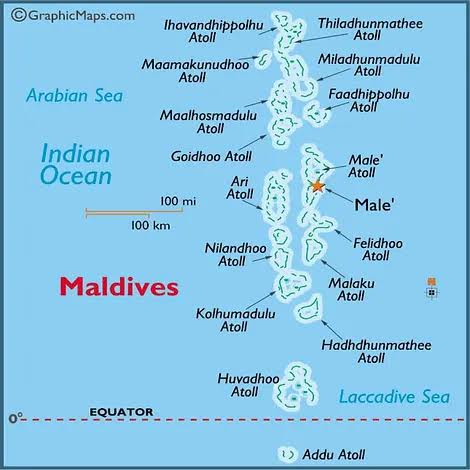
Picture a scattering of turquoise dots on a map, floating just southwest of India’s southern tip. That’s the Maldives — a nation that looks almost too delicate to be real, and in many ways, it is one of the most fragile places on Earth.
A Country Built on Sunken Mountains
Here’s something most people don’t realize: the Maldives isn’t really “islands” in the traditional sense. It’s the visible tip of an enormous underwater mountain range called the Chagos-Maldives-Laccadive Ridge, which runs roughly north to south and cuts straight across the equator. Over thousands of years, coral grew on top of these submerged peaks, eventually breaking the surface to form the islands we see today. So technically, every island in the Maldives is a coral formation resting on a drowned mountain — a strange and beautiful bit of geological history.
Small in Size, Massive in Spread
By land area, the Maldives is tiny — just 298 square kilometers, making it the smallest country in South Asia. To put that in perspective, that’s smaller than many single cities around the world. Yet despite its modest footprint, the Maldives holds a record few countries can claim: it’s the most geographically scattered nation on the planet. Its 1,192 individual islands stretch across roughly 820 kilometers from north to south and about 130 kilometers wide — an area comparable in length to the distance between two major European capitals, except almost entirely covered in ocean.
Living on the Edge — Literally
The Maldives holds another unusual distinction: it’s the flattest country in the world. Its highest natural point rises just 2.4 meters above sea level — barely taller than a standard doorframe. This makes the nation extraordinarily vulnerable to rising sea levels, and it’s part of why the Maldives has become a global symbol in conversations about climate change. In fact, the government held an underwater cabinet meeting in 2009 to highlight exactly this vulnerability.
Capital, Coastline, and Character
The capital, Malé, is one of the most densely populated cities in the world relative to its size, packed onto a small island that functions as the political and economic heart of the country. Surrounding it, the nation’s coastline stretches an impressive 664 kilometers — remarkable for a country with essentially no interior land mass to speak of. There’s no measurable inland water area either; everything here is defined by the sea.
Why the Maldives Still Fascinates People
Beyond the postcard-perfect beaches and overwater villas, the Maldives tells a bigger story — about how life adapts to extreme geography, about the beauty and danger of living so close to the ocean, and about a nation that has built an identity entirely around water rather than land. Its islands are grouped into 26 natural atolls, each with its own rhythm, culture, and marine ecosystem.
In 2026, as sea levels and climate patterns continue to shift, the Maldives remains both a dream vacation destination and a quiet warning — a nation reminding the world just how thin the line can be between land and ocean.
About the Author